Happy New Year from M3S Surveys Ltd – Laser Scanning & Surveying 2020
The team at M3S Surveys Ltd would like to wish all clients, friends and family a Happy New Year. Let’s hope for a far better 2021! With so many problems and hurdles caused with Covid 19, from travel bans, countries closed, businesses on furlough and others closed for good we have managed to battle through the year.
We have managed to carry on with our laser scanning & surveying through out 2020 delivering a range of products including point clouds, TrueView’s, 2D CAD drawings (elevations, cross sections, floor plans etc), 3D models (Revit), Topos and photogrammetry.
The range of industries we are now carrying out laser scanning has expanded further. This now includes engineers, planning consultants, architects, engineers, fabricators – all offering a range of services within the built environment, heritage, construction, food production, water and oil & gas.
Two of the main advantages our clients have found is the speed we can accurately survey with laser scanning (minimal to zero interruption to business, even less out of hours!) and the ability to re-visit the site through Leica Jet Stream Viewer on their desk top.
Here are a few images of some of the work we have been carrying out:

Happy New Year From All At M3S Surveys Ltd

Leica P40 – Laser Scanning & Surveying

Swan Engineering ( https://www.m3s-surveys.com/swan-engineering-fabrication-onsite-engineering/ )
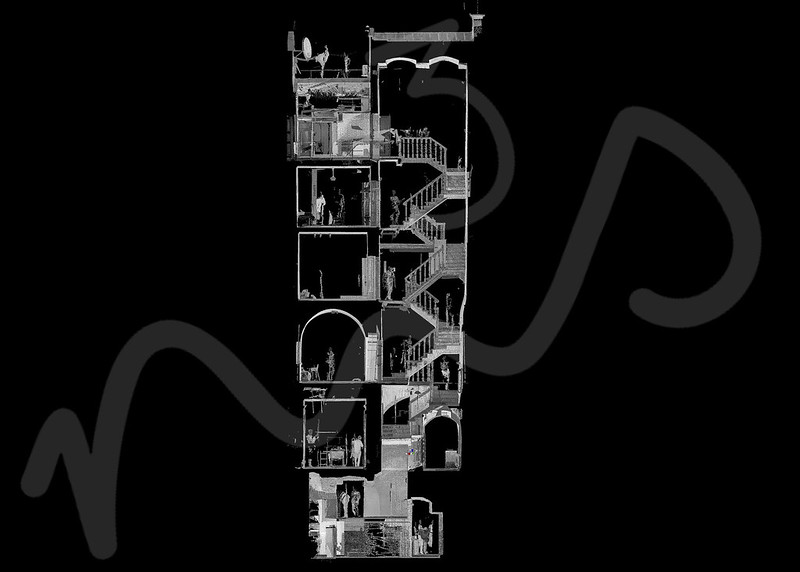
Slice Through Point Cloud From Our Laser Scanning & Surveying Services

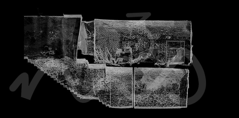
P40 Laser Scan Data – Industrial & Pipe Laser Scanning (https://www.m3s-surveys.com/services/terrestrial-laser-scanning/ )
Slice through point cloud in a basement

Scan2Bim Revit Model ( https://www.m3s-surveys.com/aec-mep-laser-scanning-and-model/ )

Plant Room & Pipe Laser Scan

Merry Christmas from M3S Surveys Ltd ( https://www.m3s-surveys.com/merry-christmas/ )
M3S Surveys Ltd Services:
Terrestrial Laser Scanning (TLS) – https://www.m3s-surveys.com/services/terrestrial-laser-scanning/
Building Surveys (MBS) – https://www.m3s-surveys.com/services/measured-building-surveys/
Topographic Surveys – https://www.m3s-surveys.com/services/topographic-surveys/
Photogrammetry – https://www.m3s-surveys.com/services/photogrammetry/
Aerial Surveys – https://www.m3s-surveys.com/services/aerial-surveys/
Spatial Data Analysis & Processing – https://www.m3s-surveys.com/services/spatial-data-analysis-processing/
Links:
3D Revit Model – https://www.autodesk.co.uk/products/revit/overview?plc=RVT&term=1-YEAR&support=ADVANCED&quantity=1
Leica P40 Laser Scanner – https://leica-geosystems.com/en-gb/products/laser-scanners/scanners/leica-scanstation-p40–p30
Leica RTC 360 Laser Scanner – https://leica-geosystems.com/products/laser-scanners/scanners/leica-rtc360
2D Cad Drawing – https://www.autodesk.co.uk/products/autocad/overview?plc=ACDIST&term=1-YEAR&support=ADVANCED&quantity=1
Laser Scanning & Surveying Services Social Media Channels
Instagram Video