Planning Applications – more than just filling in a form!
Planning applications can be quite a challenge, espeically when dealing with listed buildings. Laser Scanning & Traditional Surveying Role In Planning Applications has over the last few years become an essential combo for many surveyors. Using the total station to establish survey control and the prism/pogo for all the “non” friendly laser scanning locations such as long grass. The laser scanner is then used to collect large amounts of data that would otherwise take a considerable amount of time with a total station such as elevations and internals of a building. This data also allows the client to view the entire site in 3D from their desk or tablet.
At M3S Surveys Ltd the team has years of experience carrying out measured building and topographical surveys for planning applications. From small dwellings, country manors, University campuses to historical buildings.
From the survey data collected our team can produce a wide range of digital products that can aid not only your planning application but the entire design phase. M3S Surveys Ltd most popular products for planning is a topographical survey and building elevations. Although for larger buildings and sites with existing property a full measured survey with 3D Revit model is often also required. The team also have vast experience with heritage sites where listed buildings often require a higher detail of survey, including photogrammetry and detailed drawings to Historic England specification.
If you have been in the unfortunate position to have a planning application refused as a result of not submitting the relevant survey related plans then please get in touch and we can quote you for a suitable survey. Should it be a more complex planning matter and your site is based in Scotland, M3S Surveys Ltd can recommend Planning Objections Scotland and InterUrban Developments Ltd.
For further information on laser scanning, measured surveys, topo and bim please check out our servies page – https://www.m3s-surveys.com/services/

Surveying using a Trimble Total Station (wet morning and sunny afternoon – welcome to Scotland!)

Laser Scanning For Measured Survey: Floor Plans, elevations and topographical
Laser Scanning & Traditional Surveying Role In Planning Applications Using A Desk top site visit – Jet Stream Viewer:
The following image and video are a quick snap shot of how many of our clients are using the point cloud data on their local machines – with out the need of a fancy PC or expensive software they can view, measure and take snap shots from the point cloud. This has proven extremely valuable with in the planning process.
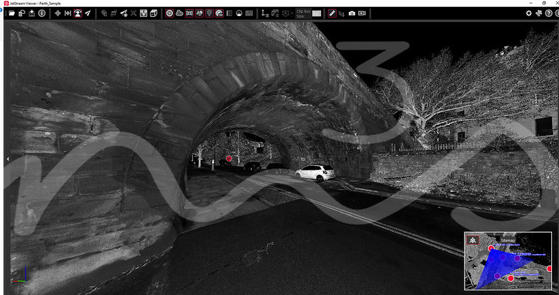
Jet Stream Viewer
Links and further information for Laser Scanning & Traditional Surveying Role In Planning Applications:
Historic England: – https://historicengland.org.uk/advice/technical-advice/recording-heritage/
HOPS Validation and Determination Guidance for Planning Applications (Living Document Last Updated October 2017) https://hopscotland.org.uk/guidance-documents/
Planning Objections Scotland – “Planning Objections Scotland provides targeted planning and surveying advice to homeowners and businesses looking to object or make representation on planning applications or planning issues.We’re here to protect your amenity and property.” https://pos.scot/
Interurban Developments Ltd – https://iudev.co.uk/
RICS Measured Survey guidance – https://www.rics.org/uk/upholding-professional-standards/sector-standards/land/measured-surveys-of-land-buildings-and-utilities/
The Survey Association (TSA) – https://www.tsa-uk.org.uk/downloads/
RTPI https://www.rtpi.org.uk/
Additional info/links to larger scale urban planning techniques and modelling:
Bentley:
https://www.bentley.com/en/solutions/3d-cities
https://www.youtube.com/watch?v=nK5PS2NfarA
ESRI Moving from BIM to GIS https://www.esriuk.com[/vc_column_text][/vc_column][/vc_row]
M3S Surveys Ltd – Land Surveying & Measured Surveying Services:
If you need any Laser Scanning related tasks mentioned on this page or require some further information on the range of CAD, Topographical and Measured Building Surveys then please feel free to contact us directly via the form on the contact page or via our social media channels on Instagram, Facebook, Twitter or LinkedIn.